|


FDOT PROJECT ON LOWER MATECUMBE - AN OPINION |
FDOT Road Project : An Opinion March 3, 2021 The first year following the vote to incorporate the Village, Hurricane Georges came to call in September of 1998. Not a terribly strong hurricane as hurricanes go, but for a new Village it was quite an education, a whole lot of work, and a huge expense. A series of storms followed in 1999, 2004 and 2005. And then Hurricane Irma in 2017. Living in the historic path of so many storms, residents of the Keys usually know just what to watch for and how to prepare. In addition to protecting their own property and the safety of family and friends, the one issue about hurricanes that residents of Islamorada, and particularly those on Lower Matecumbe, fear is whether the highway at Sea Oats Beach will survive. The Keys have a resident population of about 75,000. An estimated 50,000 of the population lives past Sea Oats Beach, thought to be the lowest lying stretch of US One. After virtually every Keys hurricane since incorporation, as well as a couple of the tropical storms, the highway had to be cleared of sand and debris and roadway damage repaired to provide access after the storms to parts of the Keys south of MM75. Several things about this project are surprising if not shocking.
Sea Level Rise; Not Tropical Storm Surge Protection When asked about protection from hurricanes at the FDOT virtual meeting on February 23, 2021, an FDOT engineer stated that the goal of the upcoming project, is to stabilize and strengthen the highway and elevate it above the rising tides anticipated by 2040. It would not be feasible to raise the highway enough to avoid significant storm surge. FDOT believes the surge from strong storms will flow over the strengthened highway but leave it intact. FDOT is now near completion of the revetment project intended to protect the highway from storm surge. FDOT engineers were clear. Their priority is not turtles. Their priority is the highway. They seemed convinced the strengthened highway would be able to withstand significant surge. Storm surge can be mighty powerful hitting an embankment with its full force. What is the priority: do we protect the highway, property owners, or the turtle nesting beach? Can we do both? With each storm, the famed turtle nesting beach erodes a bit more. Now there is no beach at all in high tide at the north end of Sea Oats Beach. Some turtles can still nest at the south end and in front of homes on Sunset Dr. Is there an agency that should be helping Islamorada protect our sea turtle nesting beaches? Should Islamorada be doing more to help? Development of waterfront properties over the decades has certainly eliminated so many of the environmental resources of the Keys. More residents who came to the Keys for its natural beauty and for nature’s treasures need to get involved and speak up! Of course there must be a way to save sea turtle nesting beaches, especially ones that are publicly owned. But maybe not this one. US One as a dam The elevation of US One is typically higher than the properties on either side of the highway, forming an obstacle to storm surge much like a dam. This “dam” batters the nearby properties, often destroying anything lower than the height of the highway: ground level enclosures, decking, landscaping. Raising the elevation of the highway will result in the potential for significantly more damage to the properties nearby, until the surge is high enough to go over the highway. In a strong storm any space above the elevation of U.S. One is less likely to flood as the water will go over the highway instead of being constrained by the highway. This was a lesson learned back in 1935. When the railroad was built, they filled the entire distance from Upper Matecumbe to Lower Matecumbe. When the 1935 storm arrived the “Fill” acted as a huge dam, causing significant damage to the fill itself and to properties throughout the area. This is what Barbara Edgar, a nearby property owner, had to say: |
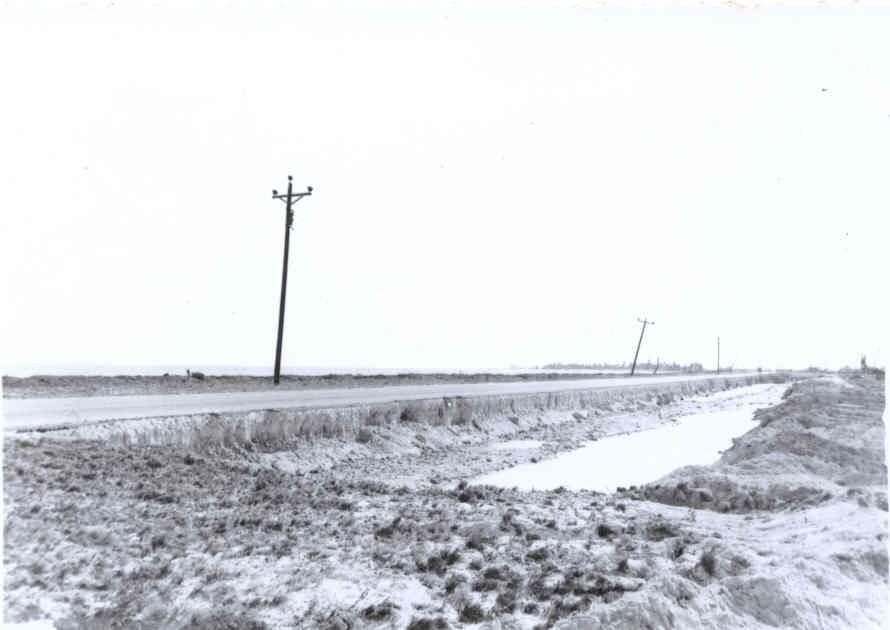
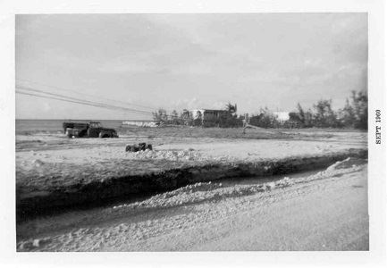
I am extremely concerned over the dam that will be built when the next strong storm or hurricane hits our area. Raising the highway will make a huge dam that will hold the water while it pounds against the highway for hours and hours destroying the fill along the side of it. It will also increase the height of the water levels and waves which will be pounding on our buildings and property for a much longer length of time until the water finally goes over the road, which it will. It will happen on the ocean side when you have a storm coming in from the ocean and on the bayside when it comes in on the gulf. Raising the highway is not the answer. Natural disasters cannot be stopped but man-made ones can. Here is a photo of the trench that was along the side of Sea Oats Beach after Hurricane Donna in 1960. The second photo is across from my parents at 75.1. I realize not many of the people here today went through Donna but it was considerably worse that Irma. We are not going to stop sea level rise as we are living on what was once a coral reef with 30 feet of water over us. Anyone in Lower Matecumbe should be concerned about raising the highway. |
| Barbara provided these photos of the highway at Sea Oats Beach after Hurricane Donna in 1960. |
|
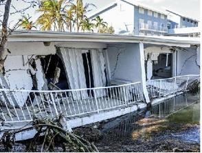
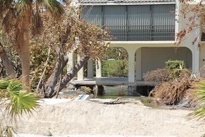
| Consider the damage done to properties near Sea Oats Beach during Hurricane Irma. Storm surge is powerful. We all remember the condo that collapsed. And the nearby home where the storm surge eroded away the land under the ground level slab. |
|
The impact of “sea level rise” by 2040 is 20 years away. But the next major hurricane could come at any time and hit with all its fury. Surely there should be an appropriate plan that will both protect property owners from an elevated highway dam and assurance that this critical section of highway will not undermined or washed away. Drainage onto Village-owned Right of Way On February 10, 2005, FDOT provided a quit claim deed for 50’ of right of way on Lower Matecumbe, bayside, and the Old Highway on the other three islands. The council accepted the gift from FDOT by resolution, thus accepting the maintenance as well. But does that alter any responsibility FDOT may have to assure the runoff from US One does not flood the Village owned portion of the right of way? Surely the two governments can work together to resolve this issue. |
