|

|

LAND USE: A BRIEFING
Zoning Basics, Zoning Map, and Village Code
Future Land Use Maps (FLUM) designations indicate the intended use for a particular area, while Zoning districts more specifically define allowable uses and contain the design and development guidelines for those intended uses.
Zoning is the division of a community into different districts (zones) in which certain activities are prohibited and others are permitted.
Zoning is a planning control tool and the way governments regulate the physical development of land based on its usage, purpose, environmental features. It defines the rules that govern how our community can be developed. The purpose of zoning is to protect and conserve the value of land within the community and assure property uses are compatible.
WHY DO WE NEED ZONING ANYWAY?
- Protects and enhances property value.
- Conserves existing neighborhoods.
- Prevents the mixing of incompatible land (think strip club next to a preschool).
- Provides better lot arrangement, protecting recreational areas and open spaces.
- Protects environmentally-sensitive areas.
- Restricts height and size of buildings
- Assures the infrastructure needs are available
- Gives community some control over its land uses, appearance and quality of life.
You can access the zoning laws of Islamorada by going to the Village website at www.islamorada.fl.us. Go to the “Departments” menu and click on Planning. A side menu will allow you to select GIS Maps where you can display zoning and other features of the properties in Islamorada.
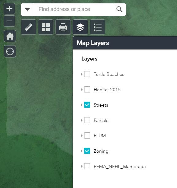
At the top left of the GIS Map you can zoom in or out, select a specific location, and/or select the type of map: click on “layers,” the stack of papers icon, to select zoning map, or a variety of other maps.
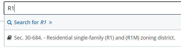
Also under the planning department you can select Village Code and then search by the zoning classification you are interested in to learn what is allowed or restricted in that zoning. For example, search for “R1” to find out about single family zoning. Then, click on the section of the code listed for that classification.
The zoning maps are a subset of the Village “Future Land Use Maps,” (FLUM), which can also be reviewed in the GIS system. The FLUM are broader classifications that are then split into the zoning districts.
Both the zoning maps and the FLUM were developed when the Village incorporated more than 20 years ago. There were months and months of public workshops, meetings, debates and then public hearings so residents could have a voice on how their specific areas were zoned.
There are reasons why property owners want to change the use of property. Click here to read the whys and why nots of zoning changes.
