|

|

ZONING CASE STUDIES - KEY HEIGHTS AND PROPERTY ON U.S. 1
| Who has read our Village Constitution, the Comprehensive Plan? Here's what we think. Proposed Change to Future Land Use Map in Key Heights Neighborhood On the agenda at the March 18, 2021 council meeting, there was a public hearing to change the Future Land Use Map for a lot fronting U.S. One on Plantation Key to Mixed Use which would allow non-residential uses. Click here to see the staff report in the agenda. |
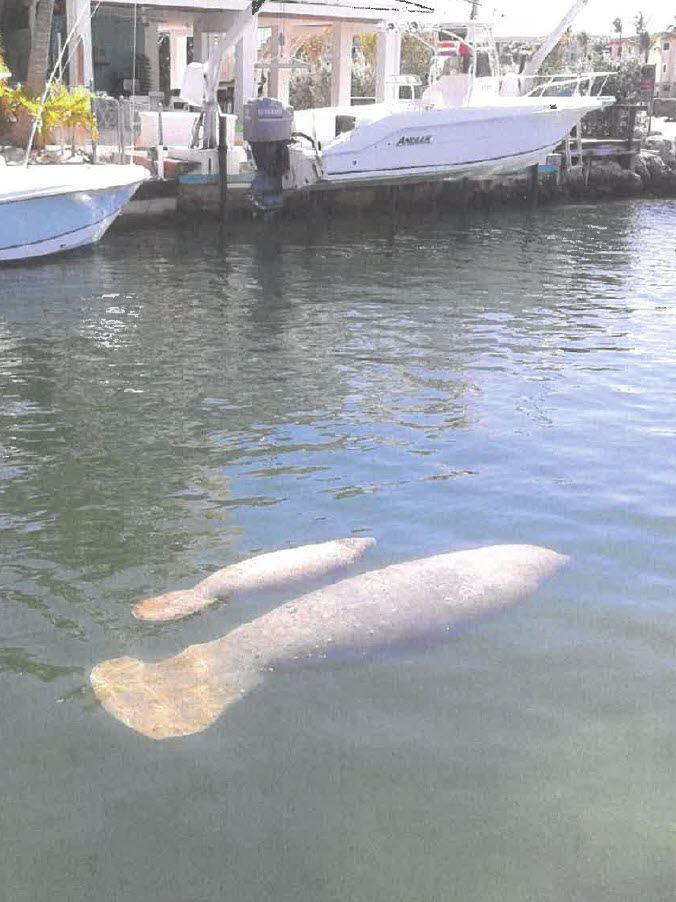
The applicant had purchased the bayside waterfront residential lot in August of 2019 knowing it was zoned for single family use. Except for the area closest to the canal, the lot is covered with thick, beautiful hardwood hammock. We have been told a bald eagle nests in that hammock. It is at the entrance to a well-established residential community – and at the end of one of the most beautiful canals in all the Florida Keys. That crystal clear waterway is home to manatee, sea turtles and a variety of sea life. Homeowners think of that waterway as their own personal aquarium. The property owner hired Pete Bacheler as a planning consultant, and within a month, they filed an application to have it re-zoned so it could be developed as a commercial business. They would need to change the Future Land Use Map (FLUM) and also the zoning map, according to Islamorada’s Comprehensive Plan. Perhaps the new owner had been encouraged that it would be an easy process as Pete’s good friend, Ty Harris, the director of planning for the Village, does not hide the fact he believes that all properties fronting U.S. One should be given commercial zoning. |
|
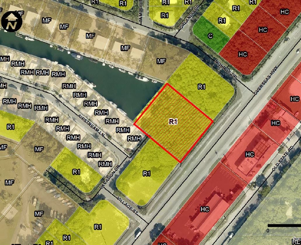
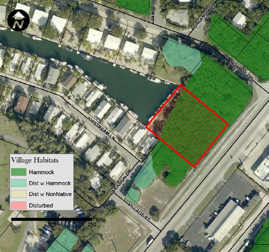
Current Islamorada Zoning Map | Current Village Habitat Map |
|
|
The Planning Department is tasked with assuring all requirements for a requested change have been met. Then, there is a multi-step process going first to the Local Planning Agency (LPA) for its stamp of approval and then an initial public hearing in front of council, then to the State of Florida’s Department of Economic Opportunity for a review, and then a final public hearing so that Village Council can pass judgement and make the final decision. That’s where this item is now in the process.
An entire residential community was unnerved about the possibility of this significant change in its quiet neighborhood and the impact on its waterway and its inhabitants. But, the process moved on and the final public hearing took place at the Thursday meeting.
Some members of the new council have limited land use experience and limited understanding of our complex Comprehensive Plan, our local constitution, as it is referred to.
You can find our Comprehensive Plan: ISLAMORADA: THE VILLAGE THAT RECLAIMED THE KEYS, under Planning Department in the Village website, www.islamorada.fl.us, a 312-page document.
Vice Mayor Pete Bacheler, a land use consultant, declared a conflict of interest as the applicant is a former client and Bacheler submitted the original application for the change.
The applicant was represented by Attorney Jim Lupino who presented the case. The applicant apparently did not attend the Zoom meeting. Just one member of the public supported the change, Don Horton, a local building consultant. Several attorneys spoke as to the legal reasons the change should be rejected. Numerous other members of the public spoke eloquently about the reason why the change to their neighborhood would be detrimental.
Councilman Mark Gregg has extensive background as an attorney and a landowner who has had numerous hearings himself and deals regularly with the planning department with his own ongoing development projects. Until elected to the council, Gregg was a member of the LPA when the application for the map change was unanimously approved by them.
Following long and emotional testimony by the neighborhood opposing this change, Gregg took charge to guide the council discussion and help the more novice council members. He seemed to be attempting to paint a picture refuting the opposing testimony and supporting commercial zoning.
It seemed obvious to observers that the staff, recommending approval, was doing what they could to sway the vote in favor of the applicant.
The staff report seemed weak at best. Among other issues, it indicated that this FLUM could potentially result in adding almost 100 trips a day to an already overcrowded highway, but indicated that was acceptable.
The staff report acknowledged that the property contained mostly hardwood hammock except the area nearest the water, but that the hammock is low quality. It did not explain that the “low quality” designation is not because of the quality of the trees, but rather because of the relatively small size of the lot.
All adjoining lots are residentially zoned. If zoning is changed for this lot, this would certainly be classified as spot zoning, usually a planning no-no.
The applicant is required to demonstrate there is a need for more Mixed Use Zoning. We all know of numerous non-residential properties along U.S. One that have been sitting empty, some for years. Why more?
It was disappointing there were only two members of council, Henry Rosenthal and Buddy Pinder, that understood and cared about the impact of this change on the neighborhood, our community, our environment and our limited infrastructure. Thankfully, only two votes were needed and the vote to change the map failed. A tie vote means the item is not approved.
While our community should be delighted this spot re-zoning in a residential neighborhood was rejected, it was a close call. The next time, it could be your neighborhood. And it could be the neighborhood that loses the battle.
Morgan Bailey is a student at Coral Shores. She gets it! Perhaps she could be a future village planner or member of council! This was her statement:
Let’s make certain the staff and the Village Council remember the people who live here, our quality of life, our precious environment, limited infrastructure and the standards we established in our Comprehensive Plan. |
|

What does the Comprehensive Plan say?
Looking at the staff report, it appeared that even the planning staff could use a Comp Plan review.
Reading from the very first goal in the Comprehensive Plan:
GOAL 1-1:IMPLEMENT FUTURE LAND USE VISION.
That the Village incorporated to create a Comprehensive Plan to reclaim the Keys by conserving, preserving, and retaining our remarkable assets — our waters and natural environment — and our quality of life;
That the Village is and must continue to be synonymous with sport fishing, diving, the Everglades National Park, the living coral reef, Indian Key, Lignumvitae Key, Shell Key, Windley Quarry, and many species of fish and fowl;
That the Comprehensive Plan must further understanding of the ecological limits of our Keys and prohibit any further degradation of our natural resources by incompatible land and marine activities such as casino boats, sea planes, personal watercraft, and other watercraft that are operated improperly; and
That the Comprehensive Plan must describe public and private actions needed to protect and retain the Village’s waterways and natural resources comprising our unique ecosystem as well as preserve the quiet solitude of the backcountry.
Policy 1-1.1.1: Protect Residential Areas From Incompatible Development. Stable residential areas shall be protected from encroachment by incompatible development.
Policy 1-1.1.2: Ensure Orderly Land Use Transition
Policy 1-2.1.13 Future Land Use Map Amendments. Applicants for FLUM amendments that increase density/intensity shall provide a needs analysis
Policy 1-2.1.14: Criteria for Future Land Use Map (FLUM) Amendments The Village Council shall make its determination on proposed FLUM amendments on legitimate public purpose.
However, in no event shall an amendment be approved which would result in an adverse community change
Policy 1-2.3.3: Residential Medium (RM). This designation is intended to provide stable, single family neighborhoods and allow for uses which further the peaceful enjoyment and high quality residential character valued by Village residents.
Policy 1-2.4.1: Guide the Location of Commercial Uses and Revitalize Commercial Areas. Mixed Use (MU) is the only FLUM category in which commercial uses shall be permitted. The general pattern of commercial land uses in MU shall:
1.Prevent negative impacts on the fragile coastal ecosystem by directing commercial development away from environmentally sensitive lands and critical habitat;
2.Revitalize all existing commercial areas and further distinguish Village Activity Centers;
3.Restrict the scale and intensity of commercial development outside of the Village Activity Centers and other appropriate areas in the Village;
4.Promote safe and efficient vehicle, cyclist and pedestrian movement;
5.Prevent or minimize Village costs to provide infrastructure;
6.Avoid encroachment of incompatible commercial activity into established residential neighborhoods;
7.Enhance the unique character of the Village’s commercial land uses through incentives for buffer yards and landscaping
Policy 1-2.4.3: Commercial Uses Located Outside of Village Activity Centers. Commercial uses adjoining residential canals, except commercial fishing uses, shall be limited to fully enclosed uses of medium to low intensity.
GOAL 1-3: LIMIT GROWTH WITHIN THE VILLAGE. Islamorada, Village of Islands shall manage the rate of development and population growth to promote small-town ambiance, improve quality of life for residents, enhance and protect natural resources and environmental quality unique to the Florida Keys, comply with adopted level of service standards for public facilities
OBJECTIVE 1-4.5: PROTECT NATURAL RESOURCES. Land Development Regulations shall ensure that development and conservation activities protect natural resources
Policy 1-4.5.1: Manage Environmentally Sensitive Lands, water resources, wetlands, upland hammocks, transitional areas, wildlife corridors, sea grasses, the coral reef, other living marine resources and other environmentally sensitive resources…
